

We made it to the Tamar. Our first overnight trip!
We dropped anchor at Deep Hollow in West Arm at 0700 this morning after leaving St. Helens yesterday at 0830. The trip was planned out in some detail, given the tidal critical nature of it at three points of the passage.
Back in St. Helens, we had a chat with the IGA supermarket closest to the pier, and arranged our meat order to be cryo-vacced and frozen (at no extra charge, which was nice of them). I had checked our order in their freezer the day before departure. Did you know that freezers are kept at around -20 degrees C? This one was -21 when I walked in, in t-shirt and shorts. I was in there for maybe 2 or 3 minutes and I realized I was uncomfortably cold. A minute later with the blasting cold air hitting me in the chest while I counted through our supplies, I suddenly thought that if I was stuck in here for 15 minutes, I might not make it out. Certain more sensitive parts of my anatomy had a ache in them for the rest of the day!
We took on 117 litres of diesel (the total used in our trip so far since filling up at Christmas 2010 in Kettering) and topped up our water tanks, then loaded on food. That evening we had Bruce, our next door neighbor, on board for some farewell drinks. I had been up to Bruce’s place to give him a hand with his computer a few days before. The problem was a familiar one for those in IT; he had bought a new computer and couldn’t connect it to his plotter because it required a serial interface. I don’t know any PC that comes with serial ports these days, but it was a simple matter to call Jaycar for the right bit and get them to mail it to him.
Bruce is a sign writer. He’s got this big scanner and a PVC vinyl plotter/cutter set up in his garage, with reels and reels of all sorts of adhesive PVC vinyl all over the place. His boat PATTY II, is a converted fishing boat, with the wet well removed and some accommodation built in. She has bricks down in the bilge as ballast. On a rough trip, the garboard had worked and a split opened up in the planking up near the stem. Bruce had removed a lot of the bricks and had them stacked in various piles through the boat while he hunted the leak down. He hurt his wrist getting all the weight out looking for the leak. Remind me to never go to sea in a boat with loose brick ballast. It damages the planking and god help you if you get knocked over and the whole lot shifts.
We used to have our boat registration information on boards lashed to the railing up forward. unfortunately some heavy weather had damaged them and we hadn’t got round to replacing them yet… As Bruce had the means to print our new registration stickers, and I could stack his bricks back into the bilge of PATTY II for him, we quickly came to an arrangement! ERIK now has some nice new registration numbers on the forward part of her coachhouse, with a matching set for the dingy.
We had saved our track on the iPhone Navionics app on the way in, and I was reasonably confident that if we retraced our steps in good weather and a higher state of tide, we should be able to make it back out again. The assumption was that nothing had changed in Georges Bay or the bar way during our stay at St. Helens.
That was reason enough to go and have a chat with the guys at St. Helens Sea Rescue. They also have lots experience rescuing boats in trouble in Banks Strait and I was keen to get as much information on it as possible. Turns out the tide predictions on my Navionics charts aren’t right for Banks Strait! They use WillyWeather for tide times, so now I do too.
Regarding tides, they also told me of how the wind can hold up a tide, making it run an hour or more late if its been blowing against it for a while. They also told me of how the top one meter of water can be wind driven, rather than tidal. The tide times for NE Tassie are also really difficult to predict, they advised. Not only is there the Tassie double tide like this one at Eddystone…
…but shallow areas, like much of the east coast and the Furneaux group, are also subject barometric tides. They advised me that the tides on WillyWejather may be an hour or more out, and advised against extrapolating forward on the last date shown for subsequent tide times.
We had been chatting with Greg, a hairy old fisherman on the fast (semi-displacement) fisher NIFTY. He had advised us on how to go about traveling up the inside of the rocks, reefs and islands on the NE tip of Tasmania, and what the best weather was to do it in: “You wanna go on the first sniff of a southerly”, he said. ” What sorta engine you got.. a Yanmar? little three cylinder eh? Good engines those. Not like the thousand horsepower we got in this one but.”
“So leave Eddystone about an hour before low tide”, he continued. “You can cut Victoria Rocks real close, plenty of water but avoid Greyhound Rock, tuck in behind Eddystone for the night. You get a good southerly blowing, you’ll be fine in there.”
“You wanna watch out for Half-tide Rock when you leave. It’ll stick out like dogs balls at low tide, but at high tide its just covered. Real bastard it is. Then there’s Warantina Rock (shown on my chart as Lipstick Rock); stick to the St. Georges rocks side of that, give it plenty of room. After you go up inside St. Georges Rocks, swing inshore to avoid a submerged reef (called Leprena Rocks, I later found out). Then you are all clear! Just avoid Black Reef and Mussel Rocks, breaks nasty there it does, and shoot up the inside of Swan.Troy, my son, he’ll show on the computer thingy, he’s got all the charts there, I’m no good with it. You can go up inside Fosters Island, save you a bit of time on the trip, eh?”
Sounds simple. Not.
We talked about the weathe toor. The challenge is that the southerly on the leading edge of a high pressure system will be a westerly in Bass Strait, giving a nice ride up the coast but then a wind against tide situation in Banks Strait. Go on the last part of low pressure system and you get the same thing. I have been through Banks Strait with a 25kt nor’westerly against the tide and it was truly horrendous. I vowed at the time that I would never knowing put myself or my family in that situation if I could help it.
After much contemplation of the synoptic charts, the trick turned out to be to wait for a high pressure system to pass over Tasmania, rather than to the north of us as they usually do. That way we can catch the nor’easterly or easterly flowing airstream at the top of the pressure system, rather that battle against the westerly airflow found at the bottom of them.
That would, however, mean no taking shelter at Eddystone on the way up, as the north side would give shelter in the southerly, but become a lee shore when the wind swung to the east. We would have to do the trip through Banks in one hit. A southerly on the east coast is often a westerly on the north. so we would have to time it to ride the southerly up and be in the right place at the right time to get the easterly. Arrive too early and battle a westerly, arrive too late and be caught by the nor’easter as a headwind.
So, now we had an idea of the locale, some maybe accurate tidal times, and an idea of the weather we needed. We just had to wait for it show up.
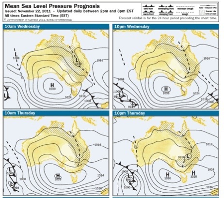
Two weeks later, a low pressure system over central Australia brought rain to places that hadn’t seen it for years. It also forced a high pressure cell coming in from the Indian Ocean to travel a lower, more southerly course than usual. I could see it coming on the seven day forecasts from MetVuw. It wasn’t until I saw it on the 4 day forecast from the BOM that I thought we really might make it.
It looks like we were going to get our weather.
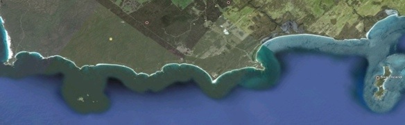
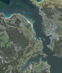
St Helens to EddyStone Point
The night before was supposed to be putting everything away for the passage, getting foul weather gear out, harnesses and tethers, warm clothes, etc. What actually happened was that discovered that the night light for our compass used the same plug as I had been using to run my iPhone out in the cockpit. I fitted another waterproof plug only to find it blew the fuse every time I switched it on. Three fuses and two hours later, I had completely fabricated a new red LED compass light using some of the old fitting and threw the old incandescent bulb out. I find it deeply satisfying being able to go to my spare “bits and pieces” draw and be able to build something eminently serviceable from spares. It was a bit unsatisfying going to bed knowing the boat wasn’t ready to sail….
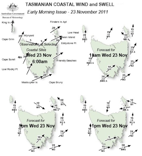
…so we got underway only 30 minutes late. The southerly was coming in as forecast and our passage out mid-tide was certainly rapid. At one point were doing nine knots, three meters from the shore in two and a half meters of water…. don’t blink!
Earlier that day I pulled the 24 coastal weather forecast from the BOM:
Not a smooth trip up the coast, but it was the best weather we’d seen in nearly 3 weeks for getting through the infamous Banks Strait.
We came out into the bar way with three meters under us, rounded up into the wind and set all sail. Bearing off we made our way around the rocks off the point and were soon running over the occasionally cray pot marker buoy at 6.5 knots. The southern swell had starting building the afternoon before and was up to about 1.5 to 2 meters. The boys were okay with the rolling, but Larissa wasn’t, and it wasn’t long before she started looking a bit green around the gills.
We made up some our lost time and got to Eddystone Point at 1315hrs, 30 minutes before the low tide forecast of 1348hrs. We opted to go outside Georges Rocks,as we weren’t going to shelter behind Eddystone. I was off-watch when Larissa called me up for the course change. She wasn’t looking peachy, and confirmed she’d been throwing up a bit. I took the helm while she went below to rest, and I opted to get us out of the southerly swell by going inside Black Reef. Exciting times awaited…
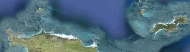
Eddystone to Swan Island
laying in a course up the inside of Black Reef, I kept an eye on the depth sounder and our speed over the ground. As the water shallowed, our speed went up, and before long we were doing 7.2 knots. I pulled down the main sail and tied it up in a seamanlike bundle on the boom. Our speed increased and the apparent wind continued to drop and back to the east. In nine meters of water we were doing 7.5 knots with rocks and reefs on either side. I had been watching a fishing boat coming south on a reciprocal heading. I was under sail and didn’t have much room to maneuver, but he was at least 80ft long and pitching heavily against the tide and the prevailing breeze. I edged to starboard as much as I dared, but he changed course too. We were still on a collision course, and I couldn’t raise him on the radio. Eventually, I decided that I drew less water than him and as much as I didn’t want to, I’d go inshore for shallower water and leave the deeper water for him. We passed 100 meters apart, plenty of room, but it didn’t feel that way. As he passed, I spotted the skipper on the deck, doing something with the fishing gear, no-one at the helm… No wonder he didn’t answer the VHF.
We hit 7.9 knots clearing Black Reef then Musselroe Point. I changed course for the middle of the channel underneath Swan Island and watched the speed over the ground slow down as we entered deeper water. Phew…
Clearing Tree Point, I welcomed the boys and ERIK to the North coast of Tasmania. We have sailed the entire east coast of Tasmania! Yay. We got in touch with Coast Guard Tamar and advised them of our trip plans, and let them know we’d be in touch again when we cleared Cape Portland.
Sailing under Swan was uncomfortable. It was 1700hrs and the easterly wind was building, and I was anxious to get out of these waters. The westerly swell from Bass Strait was coming in, meeting the southerly swell from the east coast, and a north easterly sea driven by the wind. It was lumpy and the current made it difficult to keep a course. Larissa was now throwing up on a thirty minute schedule of her own invention, but the boys were okay.
We touched 9 knots up the inside of Swan Island; I estimate the current was at least three knots.
Swan Island to Cape Portland
Off Cape Portland lies Fosters Rocks, Fosters Island and further out, Fosters Reef. Foster was evidently a modest guy… The course planned was to take us outside all of that, but the further out into Bass Strait we went, the bigger the westerly swell became, and Larissa and the boys weren’t liking it. I decided to change course to come inside Fosters Reef, in between the reef and Fosters Island. That brought us head on to the seas and stopped the rolling motion.
However, just after we called into Coast Guard Tamar, letting them know we were off Cape Portland, a new threat to our safety arose. Stretched right across the front of us, as far around as I could see were tall breaking waves, the crests being blown off them by the easterly wind.
I told everyone to hang on, and got Larissa up from off watch below as we rushed toward them at around 7 knots. It’s quite alarming to see steep breaking waves up close… they were about two meters high, maybe a little more. The first one caused ERIK to lift her bow high and as we plummeted into the trough behind, the next broke on the foredeck. I realized that they were standing still relative to us, and a glance at the instruments showed us doing six knots over the ground. I increased our revs to punch through them and little by little we sped up despite pitching heavily. Poor Alex was hanging on to the cockpit combing watching white water sluicing down the side decks. I think we were only a few waves in when I heard him yell “DADDY! I can’t take much more of this!”. Larissa struggled over to comfort him while I concentrated on keeping the boat into the waves and looking to steer around the bigger ones when I could see them coming.
We were through in just a few minutes. I was all over with pretty quickly. The waves settled and became choppy and confused, but not breaking. Ten minutes later we were rolling down an easterly sea with the wind behind us and the light of Waterhouse island ahead.
Cape Portland to Tenth Island
Larissa told me she was coping, and it was the end of my watch, so I went below all standing and got some sleep.
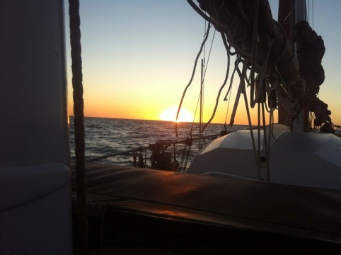
The wind died and Larissa struggled to get the jib down and stowed. the jib downhaul had become tangled in the rough conditions earlier and it took her a while to free it between throwing up. She did, however, get a wonderful shot of the sun going down while we are sea.
I came on watch again three hours later at 2100hrs on the approach to Ninth Island. The course I had planned had us clearing the all the hazards in the night by at least two nautical miles, so Ninth Island was just a dark lump off to port. We rounded Ninth and set a course for Tenth Island. our speed had been dropping with the tide against us. I estimated there was a maybe a knot of eastward current.
Larissa came up at midnight for the watch till 0300. She was looking a bit better, and by the time I came on watch she was fairly perky. Apparently she hadn’t thrown up at all! Dolphins had visited during her watch, she couldn’t see them by the moonless night. But the faint starlight was enough to make out the shapes of their fins and she could hear the sigh of their breath as they broke the surface. Tenth Island was a low lump off the port bow in the indistinct distance.
Last leg of our passage… we were getting close!
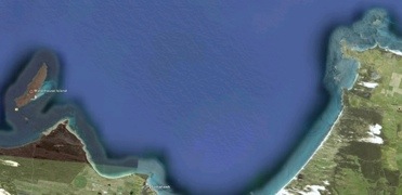
Tenth Island to Low Head and Deep Hollow
With Tenth Island rounded, we adjusted course again to make for the area off the Tamar were we could begin our approach to the channel. Low tide was 0400hrs, so I wanted to get there around 0630hrs so we would have the tide to carry us in. I adjusted our speed down to 4.5 knots so we didn’t arrive either before the tide, or before dawn. Lachie, who had wanted to stand watch with me, came up all rugged up and I got him clipped in. The poor fella was asleep up under the dodger in thirty minutes, but awoke as the sky to the south started to brighten. Dawn was coming at last!
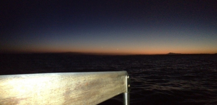
Dawn started as a glimmer in the south. Little by little the sky brightened and the stars faded. The moon came up; the thinnest sliver I have seen, but it too faded as the sky brightened:
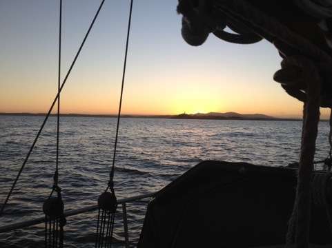
Happily, we timed our arrival at the Tamar perfectly. Here’s a shot of the sunrise over Low Head light, on the approach to Tamar.
Navigating the marks coming up the Tamar was straight forward. We kept an eye on the AIS for any shipping that might run over us, but the only two signals were from vessels up the river tied up at Bell Bay.
It was just beautiful coming up the Tamar River after our passage at sea. The rolling green hills, the birds singing… the smell of land. You really can smell it!
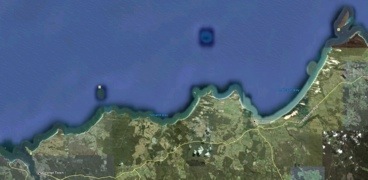
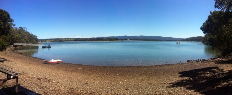
We headed up West Arm to drop anchor at Deep Hollow, a wonderful sheltered anchorage just up from Beauty Point… then we went to bed and blissfully slept!
At anchor in Dark Hollow

Later that afternoon we went ashore for a bit of an explore:
Tonight we got news that drama and bad weather had befallen our friends, also traveling up the east coast. We had planned to meet them here for a curry night and much revelry, but alas it was not to be. So tomorrow we’ll head up the river on our own and explore the delights the Tamar has to offer.
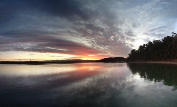
I have just checked the forecast, apparently we can expect thunderstorms tomorrow morning… I believe it, the sun set tonight was spectacular.
4 Responses to St. Helens to the Tamar